How to Find Hole in the Wall Waterfall on Vancouver Island

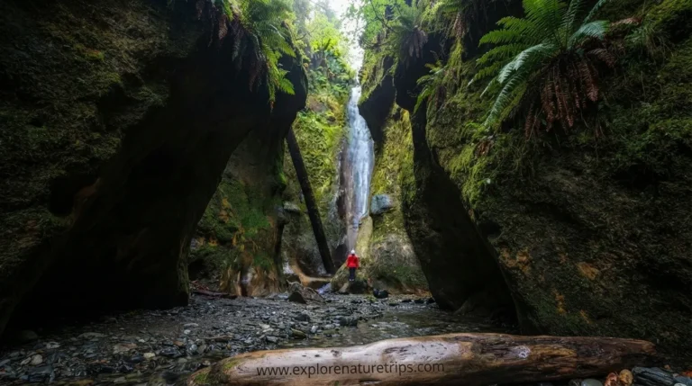
Hole in the Wall is one of the more unusual short stops near Port Alberni on Vancouver Island. Rather than requiring a long backcountry hike, the route leads through a forest to a large opening cut into a rocky ridge, where water from Roger’s Creek passes through the opening.
The walk is generally easy, but finding the correct starting point can be more difficult than the hike itself. Parking is limited, the trail entrance is not always clearly marked, and Highway 4 adds an important safety consideration.
Depending on where you park and which route description you follow, the complete walk is roughly 1.3–2 km, while the actual walk to the hole can take less than 15 minutes. Some visitors spend 30 minutes to 1 hour exploring the area.
Where Is Hole in the Wall?
Hole in the Wall is located near Port Alberni on Vancouver Island, alongside Highway 4.
One route places the attraction approximately 3.5 km outside Port Alberni, while another places the area around 6.5 km north of downtown Port Alberni. These different measurements reflect the different reference points used by the guides.
The trail area is also associated with Coombs Country Candy, which sits across Highway 4 from one of the commonly described access points.
If you are approaching from Victoria, one estimates the drive to the trailhead at around 2 hours.
How to Find the Trailhead
Finding the actual trail entrance is an important part of the trip because the entrance is not prominently marked.
The four guides describe a few useful clues:
- Look for the roadside parking area near the Hole in the Wall access.
- Watch for the forest entrance rather than expecting a large trail sign.
- One route mentions a “Hole in the Wall” sign attached to a tree.
- Another describes red paint markings on a tree shortly after entering the woods.
- The trail entrance is located close to Highway 4.
- If using the parking area near Coombs Country Candy, remember that Highway 4 must be crossed.
The trail can therefore feel less obvious than the short distance suggests.
Parking Options Near Hole in the Wall
Parking is one of the most important practical considerations.
A small pullout is described on the south side of Highway 4. One guide estimates that it has room for approximately 3 cars, while another describes a nearby trailhead area as accommodating around 5 cars.
That means parking can fill quickly.
Another option described by the guides is the larger parking area associated with Coombs Country Candy. However, visitors should not simply treat private business parking as public trail parking. One specifically advises against parking there unless you are using the business.
The practical takeaway is simple: arrive prepared for limited parking and do not assume a large public trailhead exists.
Highway 4 Crossing Safety
If you park on the opposite side of Highway 4 from the trail, crossing the highway becomes part of the outing.
The guides repeatedly emphasize caution because vehicles travel quickly along this road.
Before crossing:
- Stop completely at the roadside.
- Look carefully in both directions.
- Wait for a safe gap.
- Cross directly rather than lingering on the roadway.
- Keep children and dogs close.
- Do not assume approaching traffic will slow down.
If a safe parking option is available on the same side as the trail, it can make the visit simpler.
What Is the Hole in the Wall Trail Like?
The route is short and generally considered easy, although some descriptions rate it closer to easy-moderate because of uneven terrain.
The forest section can usually be completed in less than 15 minutes when walking directly toward the attraction.
The full outing is longer because visitors often stop to explore the creek, photograph the rock opening, or investigate the surrounding forest.
Expect:
- Uneven ground
- Gravel
- Mud after rain
- Some washed-out sections
- A steeper final section
- Slippery surfaces when wet
- Limited trail signage
The elevation gain is reported at roughly 35–50 m, so this is not a completely flat walk.
How Long Does the Hike Take?
The four guides provide several useful time estimates.
The shortest estimates put the walk to Hole in the Wall at less than 15 minutes. Another description gives approximately 15–20 minutes.
For the complete outing, the estimates increase to around 30 minutes to 1 hour.
One recorded outing took approximately 32 minutes of moving time, while another guide lists roughly 30 minutes for the return hike.
A realistic planning range is therefore:
| Activity | Approximate time |
|---|---|
| Walk directly to the hole | <15 minutes |
| Longer direct route | 15–20 minutes |
| Return hike | ~30 minutes |
| Exploring + photographs | 30 minutes–1 hour |
How Far Is Hole in the Wall?
The providers provide slightly different measurements:
- 1.3 km from one trail description
- Approximately 2 km for another return route
- About 1/2 mile in one description
- Another section refers to approximately 1 mile
These numbers should not be treated as contradictory trail measurements. The guides use different starting points and route descriptions.
For trip planning, 1.3–2 km is the most useful combined range from the four sources.
What Makes Hole in the Wall Unique?
The attraction is not simply a waterfall.
The most unusual feature is the large opening through the rock. Roger’s Creek passes through the opening, creating the distinctive scene that gives the location its name.
The surrounding area combines:
- Forest
- Shale and sandstone
- Rocky creek edges
- A small waterfall
- Historic water infrastructure
- A distinctive rock opening
The result is a short walk with several things to see rather than a hike that depends entirely on the waterfall.
Is Hole in the Wall Natural?
One of the most important details from all four is that the opening is man-made.
It was created as part of Port Alberni’s former water-supply infrastructure. A water pipeline passed through the rock, creating the opening visitors see today.
The historical descriptions connect the feature with the water system around Rogers Creek.
This is an important distinction: the hole may look like a natural geological formation, but the historical descriptions consistently explain that its present form is connected to human engineering.
The Water Pipeline History
The historical details provide an extra reason to visit the site.
Port Alberni’s water infrastructure developed through the 1910s–1940s. A particularly dry summer in 1940 is associated with later improvements involving a wooden water pipe.
The pipeline eventually passed through the rock opening.
The pipe was later removed in the 1960s, but the opening remained.
Some historical remnants are still described around the site, including a concrete structure on the opposite side of the creek and other evidence of the former water system.
This history changes how the attraction should be viewed. It is not simply a waterfall stop; it is also a small piece of Port Alberni’s infrastructure history.
What Is the Waterfall Like?
Water flow can vary significantly.
During periods of stronger creek flow, water passing through the opening creates the most recognizable waterfall scene.
The guides particularly point toward late fall, winter, and early spring as better periods for stronger water flow.
During drier conditions, the waterfall can become little more than a trickle.
A large tree stump near the opening can also affect the flow by acting like a small natural dam.
This means the appearance of Hole in the Wall can be very different depending on recent rainfall and seasonal conditions.
Can You Swim at Hole in the Wall?
They describe wading and swimming possibilities, but water conditions matter.
During warmer periods, visitors may enter the creek or wade near the rocks. However, the water can remain cold, and creek conditions can change after rainfall.
One May visit described the water as very low, with the author able to cross the creek and reach the opening. At that time, the water was only around knee depth in the explored area.
So swimming should not be the main reason for planning the trip. The waterfall, rock opening, forest, and historical features are the more consistent attractions.
Is the Trail Difficult?
For most visitors, the hike is easy, but the terrain prevents it from being a completely effortless walk.
The main challenges include:
- Gravel
- Uneven forest ground
- Mud
- Slippery surfaces
- Washed-out areas
- A steeper final section
- Potentially wet rocks near the creek
The elevation gain of approximately 35–50 m is modest, and the short distance makes the outing manageable for many hikers.
Ordinary walking shoes may be sufficient during dry conditions, while wetter conditions call for footwear with better grip.
What Should You Bring?
Because there are no facilities at the trail, basic preparation is useful.
Consider bringing:
- Drinking water
- Suitable walking shoes
- Extra socks
- A phone
- Weather-appropriate clothing
- Water shoes if you plan to enter the creek
- A small picnic if you want to stay longer
- Basic hiking essentials
If conditions are wet, footwear with good traction becomes particularly valuable.
Can You Bring a Dog?
The guides indicate that dogs can accompany visitors, with control and a leash recommended/required depending on the route guidance.
The combination of a short trail and forest environment can make it an appealing stop for dog owners, but the Highway 4 crossing means dogs should remain close and controlled.
When Is the Best Time to Visit?
For the strongest waterfall conditions, the information favors:
- Late fall
- Winter
- Early spring
These periods can provide more water flowing through Roger’s Creek.
Summer can still be enjoyable for exploring, photography, and wading, but the waterfall may be considerably smaller.
If your priority is the waterfall itself, seasonal water flow is more important than simply choosing the warmest weather.
What to Expect After Rain
Rain can improve the waterfall but make the trail more challenging.
After wet weather, expect potentially:
- Muddy ground
- Slippery gravel
- Wet rocks
- Stronger creek flow
- More difficult creek access
The same weather that makes the waterfall more impressive can therefore make the walk less comfortable.
A good approach is to enjoy the stronger water conditions while remaining cautious around the creek and rock surfaces.
Photography Tips for the Hole
The unusual rock opening makes photography one of the main reasons to stop.
The guides mention logs near the waterfall that can create interesting viewpoints, but these may become slippery.
For safer photographs:
- Stay on stable ground.
- Avoid climbing wet rocks.
- Keep away from unstable cliff edges.
- Check logs before stepping onto them.
- Use the rock opening as the main natural frame.
- Photograph the creek from several angles.
The combination of the opening, flowing water and forest provides a distinctive subject even when the waterfall is small.
A Simple Visit Plan
For a straightforward visit, use this sequence:
1. Choose your parking carefully.
Look for the limited roadside parking described by the guides rather than assuming there will be a large public lot.
2. Be extremely careful around Highway 4.
If you need to cross, wait for a genuinely safe gap.
3. Locate the forest entrance.
The trail is not always clearly marked, so watch for the described signs and tree markings.
4. Follow the short forest route.
Expect roughly 15 minutes or less for a direct walk under favorable conditions.
5. Reach Roger’s Creek.
The rock opening should become the obvious focal point.
6. Explore carefully.
Take photographs, look at the historical remains, and enjoy the creek.
7. Allow extra time.
A total visit of 30 minutes–1 hour gives you more time without turning this into a long hike.
Frequently Asked Questions
How long does it take to walk to Hole in the Wall?
The shortest route descriptions estimate less than 15 minutes, while another gives approximately 15–20 minutes. Allow additional time for photographs and exploring.
How far is the Hole in the Wall hike?
The four guides give distances from roughly 1.3 km to 2 km, depending on the starting point and route. Some descriptions also give approximately 1/2 mile to 1 mile.
Is Hole in the Wall an easy hike?
Yes. It is generally described as easy, although uneven ground, mud, gravel,l and a steeper section can make it closer to easy-moderate in some conditions.
Is Hole in the Wall natural?
No. They explain that the opening is man-made and connected to Port Alberni’s former water pipeline system.
When was the pipeline removed?
The former water pipeline was removed in the 1960s, while the rock opening remained.
What happened in 1940?
The historical account connects a dry summer in 1940 with changes to Port Alberni’s water infrastructure, including the use of a wooden water pipe.
Where do you park for Hole in the Wall?
Parking is limited. One guide describes a small pullout with room for approximately 3 cars, while another estimates a nearby area at around 5 cars. Parking near Coombs Country Candy is another described option, but visitors should follow the business’s parking rules.
Is there a waterfall at Hole in the Wall?
Yes. Water from Roger’s Creek flows through the opening. The amount of water can vary considerably with seasonal and recent weather conditions.
How long should you spend at Hole in the Wall?
A visit of 30 minutes to 1 hour is a useful planning range. The direct walk itself can take less than 15 minutes.
Can you swim at Hole in the Wall?
They describe wading and swimming during suitable conditions, but water levels and temperatures vary. Creek conditions should be assessed carefully before entering.
Final Takeaway
Hole in the Wall is a short but distinctive Vancouver Island stop where history, forest, geology and running water come together.
The walk itself is not long: depending on the route, expect approximately 1.3–2 km, with the hole reachable in roughly 15 minutes or less on some approaches. The full experience can comfortably fit into 30 minutes–1 hour.
The biggest practical issues are not distance or elevation. They are finding the correct trail entrance, dealing with limited parking, crossing Highway 4 safely, and adjusting expectations for seasonal water flow.
If you understand those details before arriving, the short walk becomes much easier to enjoy. And once you reach the opening, the combination of Roger’s Creek, the unusual rock passage, and the area’s 1960s-era pipeline history makes this much more than an ordinary waterfall stop.

Hi, I’m Marcus! I love exploring the outdoors and discovering incredible places. Through ExploreNatureTrips blog, I share my travel experiences, useful tips, and recommendations for the best sights, trails, and destinations to visit.