Lake Huron Circle Tour: 10-Day Route, Stops, Ferry & Camping Guide
Lake Huron Circle Tour: Complete Route and Planning Guide
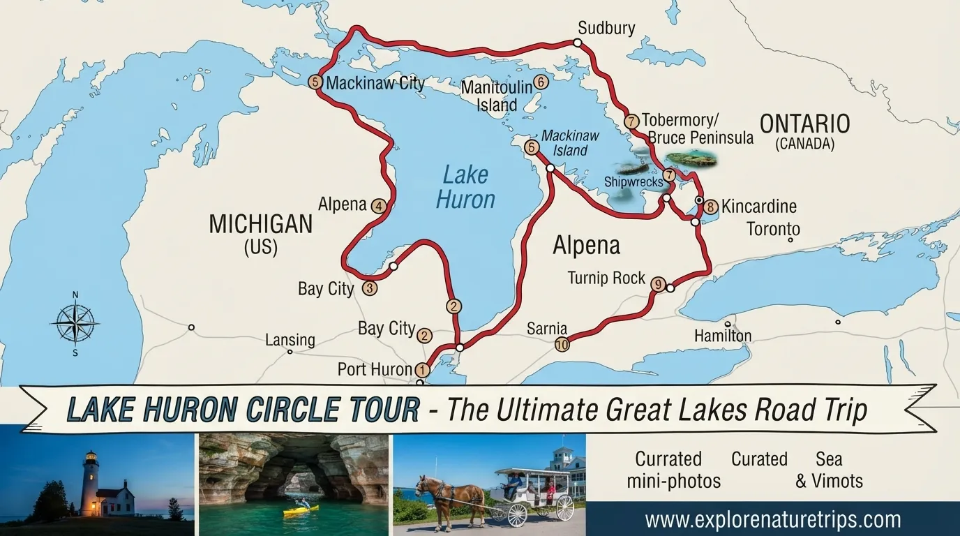
A Lake Huron Circle Tour is a road-trip route that takes travelers around Lake Huron through Michigan and Ontario. The route combines coastal communities, beaches, lighthouses, state and provincial parks, islands, hiking areas, and major bridge and ferry crossings.
A practical vacation itinerary from the Nature Seeker covers approximately 1,500 miles (2,400 km) over 10 days, beginning and ending in Port Huron, Michigan. Other route-focused sources provide the detailed highway sequence, while the camping itinerary adds campground information across both Canada and Michigan.
The route can be approached as a traditional road trip, a camping adventure, or a combination of both.
Lake Huron Circle Tour Route
The route connects communities on both sides of Lake Huron. On the Michigan side, it travels through areas including Port Huron, Bay City, Tawas City, Oscoda, Alpena, Rogers City, Cheboygan, Mackinaw City, St. Ignace, and Sault Ste. Marie.
The route then continues through Ontario before returning toward the southern end of Lake Huron.
Main Michigan Route
The detailed highway sequence can be summarized as:
Bluewater Bridge → Port Huron → M-25 → Bay City → M-13 → US-23 → Tawas City → Oscoda → Alpena → Rogers City → Cheboygan → Mackinaw City → I-75 → Mackinac Bridge → St. Ignace → M-134 → M-48 → M-129 → Sault Ste. Marie → I-75 → International Bridge → Ontario
This makes the route particularly useful for travelers who want more than a list of attractions. The highway information helps you understand how the circle connects together.
Important Highways and Route Numbers
| Route | Role in the route |
|---|---|
| M-25 | Port Huron and eastern Michigan section |
| M-13 | Michigan route toward the US-23 section |
| US-23 | Important Lake Huron shoreline route |
| I-75 | Northern Michigan connection |
| M-134 | Eastern Upper Peninsula section |
| M-48 | Upper Peninsula connection |
| M-129 | Route toward Sault Ste. Marie |
| BL I-75 | Business Loop route information |
| BS I-75 | Business Spur route information |
Several I-75 exits are also identified in the detailed highway information:
- Exit 344A
- Exit 348
- Exit 359
- Exit 392
These numbers are particularly useful for travelers following the route by road rather than simply using individual attractions as destinations.
10-Day Lake Huron Circle Tour Itinerary
A 10-day itinerary provides a useful balance between driving and sightseeing. It includes Michigan’s Lake Huron shoreline, Mackinac Island, Manitoulin Island, Tobermory, Bruce Peninsula, Fathom Five, and the southern Ontario shoreline.
Day 1 — Port Huron to Turnip Rock
Start in Port Huron and travel north toward the Lake Huron shoreline.
Key stops include:
- Fort Gratiot Lighthouse
- Lexington
- Port Austin
- Turnip Rock
- Bay City Riverwalk
The itinerary gives approximately 3.5 hours of driving for Day 1, with an overnight stay in Bay City.
Turnip Rock provides an early highlight for the trip, while Fort Gratiot Lighthouse and Lexington add historic and waterfront stops to the first day.
Day 2 — Turnip Rock and Lake Huron Shoreline
The second day continues around the eastern Michigan shoreline.
Possible stops from the itinerary include:
- Lake Huron beaches
- Turnip Rock
- Port Crescent State Park
- Lexington
- Fort Gratiot Lighthouse
This day is more focused on shoreline exploration and allows travelers to spend additional time at the attractions rather than treating the entire trip as a driving route.
Day 3 — Bay City to Alpena
Continue north toward Alpena.
Important stops include:
- Tawas Point State Park
- Tawas Point Lighthouse
- Oscoda
- Lumberman’s Monument
- Alpena Harbor
The overnight destination is Alpena.
Tawas Point combines a state park and lighthouse stop, while Alpena provides a waterfront destination at the end of the day.
Day 4 — Alpena to Mackinaw City
Day 4 follows the northern Michigan shoreline toward Mackinaw City.
Stops include:
- Sturgeon Point Lighthouse
- Forty Mile Point Lighthouse
- Ocqueoc Falls
- Rogers City
- Mackinaw City
The overnight stay is in Mackinaw City.
This section is particularly attractive for travelers interested in lighthouses, waterfalls, and small Lake Huron communities.
Day 5 — Mackinac Island
Use Mackinaw City as the base for a day trip to Mackinac Island.
The itinerary highlights:
- Arch Rock
- Fort Mackinac
- Island bicycle loop
- Downtown Mackinac Island
After exploring the island, return to Mackinaw City for the overnight stay.
The island day also gives the overall trip a break from long-distance driving.
Day 6 — Mackinaw City to Tobermory
Day 6 marks the major transition from Michigan into Ontario.
The route includes:
Mackinaw City → Mackinac Bridge → St. Ignace → Manitoulin Island → Chi-Cheemaun Ferry → Tobermory
The Chi-Cheemaun Ferry is one of the most important transportation points on this itinerary.
| Ferry detail | Number |
|---|---|
| Approximate crossing | Nearly 2 hours |
| Passenger capacity | 600 |
| Vehicle capacity | 150 |
| Main route | Tobermory ↔ Manitoulin Island |
The overnight destination is Tobermory.
Day 7 — Bruce Peninsula National Park
Spend the seventh day exploring Bruce Peninsula National Park.
Main attractions include:
- The Grotto
- Indian Head Cove
- Bruce Trail
- Cyprus Lake
- Marr Lake
Tobermory remains the overnight base.
This is one of the most hiking-focused sections of the trip, so it works well for travelers who want to balance driving with outdoor activities.
Day 8 — Fathom Five National Marine Park
The next day focuses on Fathom Five National Marine Park.
Key experiences include:
- Flowerpot Island
- Glass-bottom boat cruise
- Sea caves
- Historic shipwrecks
- Big Tub Lighthouse
The itinerary again uses Tobermory as the overnight location.
Keeping two nights around Tobermory makes the route easier to enjoy because travelers do not have to change accommodation after every attraction.
Day 9 — Tobermory to Goderich
Begin the journey south along the Ontario side of Lake Huron.
Stops include:
- Lion’s Head
- Sauble Beach
- Southampton
- Point Clark Lighthouse
- Kincardine
- Goderich
The overnight destination is Goderich.
This section returns the trip toward the southern end of Lake Huron while continuing to include beaches, waterfront communities, and lighthouse stops.
Day 10 — Goderich to Port Huron
The final day completes the circle.
The route includes:
- Grand Bend
- Pinery Provincial Park
- Sarnia Waterfront
- Blue Water Bridge
- Port Huron
The trip ends back in Port Huron, completing the approximately 1,500-mile / 2,400-km itinerary.
Lake Huron Circle Tour Camping Route
For travelers who prefer camping, the Lake Huron route can be turned into a campground-focused trip.
The camping itinerary follows a counter-clockwise direction and starts at the southernmost park in Canada. Travelers can also reverse the route or complete only selected sections.
Camping Reservation Numbers
| Reservation | Timing |
|---|---|
| Provincial parks | 5 months in advance |
| Canadian National Park reservations | February 5, 2024 |
| Michigan State Parks | 6 months in advance |
These reservation figures come from the camping itinerary and are especially important for anyone planning a park-heavy trip.
Canadian Camping Stops
The Canadian section includes 7 main stops.
| Park | Main highlights |
|---|---|
| Pinery Provincial Park | Biking, beach |
| Inverhuron Provincial Park | Sunset, sandy beach |
| Bruce Peninsula National Park | The Grotto, wildlife |
| Six Mile Lake Provincial Park | Access toward Georgian Bay Islands |
| Killbear Provincial Park | Views, sunset |
| Killarney Provincial Park | Paddling, wildlife |
| Chutes Provincial Park | Hiking, waterfalls, river gorges |
Pinery Provincial Park
Pinery has 3 campgrounds and approximately 1,000 campsites.
The Riverside campground offers electric hookups, while Dunes and Burley are closer to the beach.
Activities include:
- Biking
- Hiking
- Paddling
- Fishing
- Beach activities
Inverhuron Provincial Park
Inverhuron has 351 campsites across 3 campgrounds.
The park includes a sandy beach on its southern end, while the Chain Trail provides opportunities for walking and biking.
Georgian Bay Islands National Park
The camping itinerary gives the park an area of 13.5 sq km, or 3,335 acres, with 60+ islands and islets.
The park is accessed by boat, including the Day Tripper boat from Honey Harbour, with Beausoleil Island as a destination.
Killbear Provincial Park
Killbear contains 7 campgrounds, with 3 offering electric hookups.
The recreational trail is 6 km long, and the listed activities include:
- Hiking
- Biking
- Canoeing
- Kayaking
- Fishing
Killarney Provincial Park
Killarney covers 645 sq km, or 159,383 acres.
The itinerary notes 100+ bird species and a historic village founded in 1820. Paddling and wildlife viewing are among the highlighted experiences.
Chutes Provincial Park
Chutes includes a 6-km hiking trail featuring waterfalls and river gorges.
The park also works as a convenient camping stop for travelers moving toward Manitoulin Island.
Manitoulin Island and the Chi-Cheemaun Ferry
Manitoulin Island is an important connection point in the Lake Huron Circle Tour.
The camping itinerary gives the island’s size as:
| Manitoulin Island | Number |
|---|---|
| Area | 2,766 sq km |
| Area in square miles | 1,068 sq mi |
| Lakes | 108 |
| Major rivers | 4 |
| Indigenous communities | 6 |
It is described in the supplied competitor material as the world’s largest freshwater lake island.
The Chi-Cheemaun Ferry provides the important connection between Tobermory and Manitoulin Island.
Its stated capacity is 600 passengers and 150 vehicles, with a crossing time of nearly 2 hours.
Michigan Camping Stops
The Michigan camping itinerary includes:
- Aune Osborn Campground
- Straits State Park
- Cheboygan State Park
- Harrisville State Park
- Tawas Point State Park
- Bay City State Park
- Port Crescent State Park
- Lakeport State Park
These stops give campers another way to experience the Lake Huron shoreline without following the exact 10-day hotel-based itinerary.
Straits State Park
Straits State Park has 270 campsites across 3 areas.
The Mackinac Island ferry dock is less than 1 mile away, making the park particularly convenient for travelers planning an island visit.
Cheboygan State Park
Cheboygan State Park has 75 campsites and is approximately 30 miles southeast of Mackinaw City.
The camping information also mentions fireworks on Fridays.
Presque Isle Lighthouses
The camping itinerary highlights 2 Presque Isle lighthouses:
- Old lighthouse — built 1840
- New lighthouse — built 1870
The newer lighthouse is described in the competitor material as the tallest publicly accessible lighthouse in the Great Lakes.
Harrisville State Park
Harrisville State Park has 195 campsites.
It provides another camping option along the eastern Michigan side of Lake Huron.
Tawas Point State Park
Tawas Point State Park has 193 campsites.
The supplied camping information also notes a campground closure for updates beginning 9/3/24.
Bay City State Park
Bay City State Park has 189 campsites.
The area also includes Tobico Marsh, with 2 marsh observation towers.
Port Crescent State Park
Port Crescent State Park has 142 campsites.
Accommodation options listed in the camping itinerary include:
- Cottages
- Camper cabins
- 2 Geodomes
The supplied information notes that the campground was closed in 2024 for improvements.
Lakeport State Park
Lakeport State Park contains 2 campgrounds and approximately 250 campsites.
De Tour Village Loop
The detailed Michigan highway source includes a special De Tour Village Loop.
The route is:
M-134 / M-48 junction → M-134 → De Tour Village → North Caribou Lake Road → M-48 / Lake Huron Circle Tour
The loop is useful because De Tour Village serves as the jumping-off point for the Drummond Island Ferry.
This is an optional route feature rather than a necessary part of the main 10-day itinerary.
What Makes the Lake Huron Circle Tour Different?
The route combines several types of travel experiences into one loop.
Scenic Road Trip
The approximately 1,500-mile itinerary connects Michigan and Ontario through coastal roads, waterfront towns, beaches, parks, and major crossings.
Lighthouse Trail
Travelers can encounter numerous lighthouse stops, including:
- Fort Gratiot Lighthouse
- Tawas Point Lighthouse
- Sturgeon Point Lighthouse
- Forty Mile Point Lighthouse
- Point Clark Lighthouse
- Big Tub Lighthouse
- Presque Isle lighthouses
Hiking and Nature
The route includes outdoor destinations such as:
- Turnip Rock
- Ocqueoc Falls
- Bruce Peninsula National Park
- The Grotto
- Indian Head Cove
- Bruce Trail
- Cyprus Lake
- Marr Lake
- Fathom Five National Marine Park
Islands and Ferry Travel
The itinerary also connects several important island experiences:
- Mackinac Island
- Manitoulin Island
- Flowerpot Island
- Drummond Island access via the De Tour Village area
Highway Route vs. Vacation Itinerary
The different Lake Huron Circle Tour resources serve different types of travelers.
| If you want… | Focus on… |
|---|---|
| A complete vacation | 10-day itinerary |
| Exact road navigation | M-25, M-13, US-23, I-75, M-134, M-48, M-129 |
| Camping | Canadian + Michigan campground route |
| Hiking | Bruce Peninsula, Bruce Trail, parks and trails |
| Lighthouses | Fort Gratiot, Tawas Point, Sturgeon Point, Forty Mile Point and others |
| Island experiences | Mackinac + Manitoulin + Flowerpot Island |
| Ferry travel | Chi-Cheemaun |
| Optional northern detour | De Tour Village Loop |
This distinction makes trip planning much easier. A traveler does not need to follow every campground, highway segment, and attraction in the source material. Instead, the route can be adapted around the type of experience they want.
Lake Huron Circle Tour Planning Tips
Plan Around the 10-Day Framework
The 10-day itinerary is a useful starting point because it divides the approximately 1,500-mile route into manageable sections while leaving dedicated days for Mackinac Island, Bruce Peninsula, and Fathom Five.
Keep Tobermory as a Base
The itinerary uses Tobermory for multiple nights. This avoids unnecessary accommodation changes while exploring Bruce Peninsula National Park and Fathom Five National Marine Park.
Allow Time for the Ferry
The Chi-Cheemaun crossing takes nearly 2 hours, so ferry travel should be treated as a significant part of the day’s schedule rather than a short road connection.
Choose Your Camping Style Early
The camping route includes both Canadian and Michigan parks, with several sites having hundreds of campsites. Reservation timing can therefore become an important part of planning.
Carry a Passport
Because the route crosses between Michigan and Ontario, the supplied itinerary identifies a passport as required.
Decide Between Clockwise and Counter-Clockwise
The 10-day vacation itinerary follows a clockwise approach, while the camping itinerary uses a counter-clockwise direction.
Neither structure needs to be treated as the only possible way to travel. The direction can be selected according to the attractions and camping stops you want to prioritize.
Frequently Asked Questions
How long is the Lake Huron Circle Tour?
The vacation itinerary covers approximately 1,500 miles (2,400 km) and recommends 10 days.
Where does the Lake Huron Circle Tour start and end?
The 10-day itinerary starts and ends in Port Huron, Michigan.
Which countries does the Lake Huron Circle Tour visit?
The route travels through Michigan in the United States and Ontario in Canada.
Is a passport required for the Lake Huron Circle Tour?
The supplied itinerary identifies a passport as required because the route crosses the international border between Michigan and Ontario.
How long does the Chi-Cheemaun Ferry take?
The ferry crossing takes nearly 2 hours between Tobermory and Manitoulin Island.
How many people can the Chi-Cheemaun Ferry carry?
The supplied camping itinerary gives a passenger capacity of 600 and a vehicle capacity of 150.
What are the main stops on a 10-day Lake Huron Circle Tour?
Major stops include Port Huron, Bay City, Alpena, Mackinaw City, Mackinac Island, Manitoulin Island, Tobermory, Bruce Peninsula National Park, Fathom Five National Marine Park, Goderich, Grand Bend, Sarnia, and Port Huron.
Can I do the Lake Huron Circle Tour as a camping trip?
Yes. The camping itinerary includes 7 Canadian stops and 8 Michigan camping locations, including Pinery Provincial Park, Bruce Peninsula National Park, Killbear Provincial Park, Killarney Provincial Park, Straits State Park, Tawas Point State Park, and Lakeport State Park.
What is the best time for the Lake Huron Circle Tour?
The 10-day itinerary identifies June through September as the best time.
Is Mackinac Island part of the route?
Yes. The 10-day itinerary dedicates Day 5 to Mackinac Island, including Arch Rock, Fort Mackinac, the island bicycle loop, and downtown Mackinac Island.
What is the De Tour Village Loop?
It is an optional northern Michigan loop connecting M-134/M-48, De Tour Village, North Caribou Lake Road, and M-48. It provides access toward the Drummond Island Ferry.
Final Thoughts
The Lake Huron Circle Tour works especially well because it can be planned in several different ways without losing the character of the route. A 10-day, approximately 1,500-mile itinerary provides a strong framework for seeing both Michigan and Ontario, while the camping route offers a more outdoor-focused alternative.
The biggest planning highlights are the Mackinac Bridge, Mackinac Island, Manitoulin Island, Chi-Cheemaun Ferry, Bruce Peninsula National Park, Fathom Five National Marine Park, beaches, lighthouses, and Lake Huron waterfront communities. Whether you follow the highway sequence closely, use the 10-day itinerary, or select individual camping stops, the route gives you a structured way to explore the Lake Huron shoreline.