How to Legally Get to Observation Point When It’s Closed
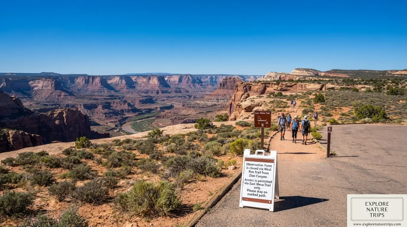
If you are planning to visit Observation Point in Zion National Park and discover that the traditional route is closed, you do not necessarily have to cancel your hike. The important distinction is that the closure affects the route, not the famous Observation Point overlook itself.
The practical alternative described across the available trail guides is the East Mesa Trail. Instead of approaching from Weeping Rock through the traditional East Rim route, hikers reach the East Mesa trailhead from the east side and then walk approximately 3.3 miles each way, or about 6.6 miles round trip, to Observation Point.
The East Mesa approach is generally moderate, with roughly 700 feet of elevation gain according to the firsthand Starlit Ridge account. Another guide gives a broader estimate of 600–900 feet, depending on the exact starting point or drop-off location.
Why Is the Traditional Observation Point Trail Closed?
The traditional approach from Weeping Rock through the East Rim Trail was affected by a major rockfall in November 2023. The East Rim approach remains closed due to material issues, with no reopening date announced.
One important source of confusion is that the Weeping Rock Trail and the longer East Rim route are not the same. The shorter Weeping Rock Trail was reported as reopening in September 2025, while the East Rim route toward Observation Point remained closed.
That means you should not assume that seeing information about Weeping Rock reopening means the traditional Observation Point hike is available.
The Legal Alternative: East Mesa Trail
The alternative route is the East Mesa Trail.
The route begins outside the main Zion canyon area, near Zion Ponderosa Ranch Resort, and approaches Observation Point from the east. The trail itself is substantially gentler than the old East Rim approach.
Here are the main figures to know:
| Detail | Information |
| East Mesa distance | 3.3 miles one way |
| Round trip | 6.6 miles |
| Elevation gain | About 700 ft |
| Typical hiking time | 2.5–4 hours |
| Difficulty | Moderate |
| Observation Point elevation | 6,521 ft |
| View above canyon floor | About 2,000 ft |
| Permit for normal day hike | None required |
| Recommended group maximum | 12 people |
Different sources give slightly different round-trip distances, ranging from approximately 6 to 7.5 miles, with one shuttle provider describing the hike as approximately 8 miles round trip. The variation is associated with different trailhead, parking, road-gate, or shuttle drop-off points.
For practical planning, 6.6 miles round trip is the clearest figure from the firsthand East Mesa hike account.
How to Get to the East Mesa Trailhead
The drive is arguably more complicated than the hike.
The general approach described is:
US-89 S → Mt. Carmel Junction → UT-9 W → Zion East Entrance → North Fork Road → Zion Ponderosa Ranch Resort → Twin Knolls Road → East Mesa Trailhead
The important point is that you are not driving to the traditional Zion Canyon trailhead.
Instead, the East Mesa trailhead is outside the main park boundary and is reached from the east side.
From the East Entrance, the Starlit Ridge guide gives these approximate figures:
| Location | Approximate distance/time |
| Zion East Entrance | 45 miles / 55 min |
| Zion Ponderosa gate | 53 miles / 70 min |
| East Mesa Trailhead | 49.1 miles / 1 hr 5 min |
| Zion Visitor Center | ~80 miles / 1 hr 45 min |
These figures are useful for understanding the east-side approach, but actual driving time can change with road conditions.
Follow the Signs Instead of Trusting GPS Alone
Cell service can be unreliable around the East Mesa access roads.
They recommend having your route available offline and paying attention to the brown directional signs for Observation Point.
The Nature Seeker account specifically warns that there are multiple turns that can look tempting, while Starlit Ridge notes that small directional signs become useful after passing the resort gate.
A practical approach is:
- Download or screenshot your route before leaving.
- Save the East Mesa trailhead location.
- Watch for Observation Point signs.
- Do not depend entirely on live GPS.
- Make sure everyone understands the route before losing cell service.
What Is the East Mesa Access Road Like?
This is where conditions can change your plans.
Most of the access road is described as a graded dirt road, but the final section can be considerably rougher. Starlit Ridge specifically identifies a deeply rutted section commonly called Beaver Road as the main trouble spot.
After rain, the same section can become very slick and difficult.
The Nature Seeker account describes winter conditions involving:
- Snow
- Ice
- Wet sections
- Deep mud
- Slippery road conditions
During that trip, the vehicle was stopped approximately 1 mile before the trailhead, and the hikers walked for about 15 minutes to reach it.
So the most important road rule is simple:
Do not force your vehicle through conditions it cannot safely handle.
Do You Need a 4WD Vehicle?
The experiences are not identical, which is important.
The Nature Seeker account recommends 4×4 or AWD for the muddy road section and describes conditions in which even a four-wheel-drive vehicle could have difficulty.
Starlit Ridge provides a different firsthand experience: the author drove a Toyota RAV4, while a Tesla Model Y was also observed at the trailhead during good weather.
The useful takeaway is therefore not simply “you must have 4WD.”
Instead:
| Conditions | Practical approach |
| Dry, good weather | Regular vehicles may reach the trailhead |
| Rough/rutted road | Drive slowly and carefully |
| Recent rain | Consider avoiding the rough section |
| Mud/snow/ice | Shuttle is the safer alternative |
| Low-clearance vehicle | Extra caution is necessary |
Road conditions matter more than simply choosing a vehicle based on its badge.
Parking Can Be a Problem
The East Mesa trailhead parking area is described as small and capable of filling on weekends and holidays.
This creates two separate problems:
- You may not find a convenient parking space.
- Trying to create an unauthorized parking spot can damage the surrounding landscape.
That is one reason the shuttle option can be useful.
East Zion Adventures Shuttle Option
If you do not want to deal with the access road or limited trailhead parking, East Zion Adventures offers transportation from Zion Ponderosa Ranch Resort.
The listed starting price is:
$7 per person, round trip
The service is for ages 4+ and transports hikers toward the East Mesa or Stave Springs areas.
The shuttle does not take hikers directly to the exact trailhead. The listed drop-off and pickup point is approximately 0.5 mile from the East Mesa trailhead.
Is a Permit Required?
For the normal East Mesa day hike describe no permit is required.
This is different from the permit requirements associated with the chain section of Angels Landing.
However, wilderness regulations still matter if you extend your trip beyond a straightforward day hike.
The Starlit Ridge guide states that:
- Group size is limited to 12 people sharing the same trail or drainage on the same day.
- Pets are not allowed, except service animals.
- Campfires are not allowed.
- Bikes are not allowed.
- Strollers are not allowed.
- Wheeled vehicles, including UHVs and ATVs, are not allowed on the trail.
- Overnight camping requires a wilderness permit.
What Is the Hike Actually Like?
The East Mesa Trail is not a constant climb.
The firsthand account describes several distinct environments during the approximately 3.3-mile walk to Observation Point:
- Ponderosa pine forest
- Scrub oak
- Desert vegetation with yucca and prickly pear
- Open meadow approaching the canyon rim
The early part is relatively shaded and sandy, while later sections become more exposed.
This makes the route quite different from the image many hikers have of a steep Zion switchback climb.
Is East Mesa Family-Friendly?
The firsthand Starlit Ridge account describes hiking the route with children aged 10 and 13.
Most of the trail was described as relatively easy, with sandy terrain and limited technical footing. A few shorter, steeper sections occur before the final approach.
That does not mean every family will experience the trail identically. Weather, heat, road conditions, water availability, and individual fitness still matter.
But the experience reported by thee suggests that East Mesa can be a more approachable option for families than an exposed route involving chains.
The Final View at Observation Point
The payoff is the enormous Zion Canyon panorama.
Observation Point sits at approximately 6,521 feet, and the viewpoint is roughly 2,000 feet above the canyon floor according to the material.
From the overlook, the reported landmarks include:
- Angels Landing
- Virgin River
- Zion Canyon Scenic Drive
- Great White Throne
The elevated perspective is one of the major reasons the hike remains worthwhile despite the additional driving required to reach East Mesa.
How Crowded Is Observation Point?
The experience can vary considerably.
The Nature Seeker account describes seeing only 2 other people on the trail and having the viewpoint largely to themselves for a period of time.
Starlit Ridge visited during Memorial Day weekend, described as the busiest weekend of the year, yet reported that the viewpoint still did not feel overwhelmingly crowded. Some visitors had to wait around 1–2 minutes for a clear photo position.
So East Mesa can feel quieter than some of Zion’s more famous attractions, but you should not assume it will always be empty.
When Is the Best Time to Go?
The information points toward late spring and fall as particularly comfortable periods.
The Nature Seeker account highlights November through March as a period when rain, cold, snow, ice, and mud can make the access road more difficult.
Starlit Ridge also warns about summer afternoon thunderstorms and recommends an early start.
A simple seasonal overview:
| Season/condition | Main concern |
| Late spring | Comfortable temperatures and wildflowers |
| Summer | Heat and afternoon thunderstorms |
| Fall | Comfortable hiking conditions |
| November–March | Mud, rain, snow, ice, nd cold |
| After heavy rain | Poor dirt-road conditions |
Why an Early Start Makes Sense
An early start provides several advantages:
- Cooler temperatures.
- Less heat on exposed sections.
- More time for the 2.5–4 hour hike.
- More time to deal with unexpected road problems.
- Less exposure to afternoon thunderstorm activity.
- Better chance of finding parking.
This is especially important because parts of the trail have limited shade and the shuttle provider specifically warns that much of the route is exposed.
What Should You Bring?
Because there is no guaranteed water source described along the trail and much of the route can be exposed, preparation matters.
Essential items:
- Plenty of water
- Electrolytes
- Sun protection
- Broken-in hiking shoes or boots
- Offline maps
- Phone/GPS with downloaded route information
- Extra layers
- Headlamp if there is any possibility of returning late
The East Zion Adventures page specifically warns that much of the trail is not shaded and recommends carrying plenty of water.
What About Restrooms and Cell Service?
Do not plan on convenient facilities at the trailhead.
The Starlit Ridge account reports no restrooms at the trailhead or along the trail. It also notes that cell service can be unreliable.
That makes a simple pre-hike routine valuable:
Use the restroom → download maps → fill water → check weather → confirm road conditions → start early.
Observation Point vs. Angels Landing
These two hikes provide very different experiences.
| Feature | Observation Point via East Mesa | Angels Landing |
| East Mesa distance | 6.6 mi round trip | — |
| East Mesa elevation gain | ~700 ft | — |
| East Mesa difficulty | Moderate | More exposed |
| Main exposure | At viewpoint | Significant on route |
| Permit | No permit for East Mesa day hike | Permit required for chain section |
| Main attraction | High canyon panorama | Exposed summit/chain experience |
Observation Point gives you a high-level perspective over the canyon, including a view toward Angels Landing itself.
Observation Point vs. the Old East Rim Route
The major difference is the type of effort.
The traditional route was approximately 8 miles round trip in the Nature Seeker material and involved substantially more elevation gain. The East Mesa route is about 6.6 miles round trip in the detailed firsthand account, with approximately 700 feet of elevation gain.
In other words, the alternative does not simply replace the old route—it changes the experience.
You trade a more direct canyon-side approach for:
More driving + less strenuous hiking + east-side logistics.
Four Things to Check Before Leaving
Before committing to the trip, verify these 4 things:
- Trail status — confirm that the route you intend to use is permitted and accessible.
- Road conditions — especially after rain, snow, or ice.
- Parking or shuttle availability — trailhead parking is limited.
- Weather — particularly summer afternoon thunderstorms and winter precipitation.
This is important because access to East Mesa can change independently from the condition of the actual hiking trail.
Common Mistakes to Avoid
Mistake 1: Driving to Weeping Rock expecting the old Observation Point route.
The traditional East Rim approach remains closed in the area.
Mistake 2: Treating East Mesa as a normal Zion Canyon trailhead.
The approach begins from the east side and involves dirt-road access.
Mistake 3: Trusting GPS without downloading the route.
Cell service can be unreliable.
Mistake 4: Driving the rough road after rain.
Mud can dramatically change road conditions.
Mistake 5: Ignoring limited parking.
The trailhead lot is small and can fill on busy days.
Mistake 6: Carrying too little water.
Parts of the route are exposed and can become hot.
Mistake 7: Assuming the viewpoint is safe simply because the hike is moderate.
The approach can feel easy while the final viewpoint remains a cliff-edge environment.
Frequently Asked Questions
Can you legally hike to Observation Point while the main trail is closed?
Yes. The material identifies the East Mesa Trail as the alternative approach to Observation Point while the traditional East Rim route is closed.
How long is the East Mesa hike to Observation Point?
The detailed firsthand account gives 3.3 miles each way, or 6.6 miles round trip. Other guides give approximately 6–7.5 miles, depending on the exact access point.
How much elevation gain does East Mesa have?
The detailed trail account gives approximately 700 feet, while another gives a broader range of 600–900 feet.
Do you need a permit for East Mesa?The trail states that no
T TThe trailates tthatno permit is required for the normal East Mesa day hike to Observation Point. Wilderness rules still apply to other activities such as overnight trips.
Can you drive a regular car to the trailhead?
The answer depends heavily on weather and road conditions. A firsthand report reached the trailhead in a Toyota RAV4 during good weather, while another account encountered deep mud, snow, and ice and stopped about 1 mile short.
Is there a shuttle to East Mesa?
Yes. East Zion Adventures lists a shuttle from Zion Ponderosa Ranch Resort starting at $7 per person round trip. The drop-off is approximately 0.5 mile from the East Mesa trailhead.
How high is Observation Point?
The shuttle provider lists Observation Point at approximately 6,521 feet in elevation.
How far above Zion Canyon is Observation Point?
The Starlit Ridge firsthand account describes the viewpoint as approximately 2,000 feet above the canyon floor.
Is East Mesa harder than Angels Landing?
The two hikes are difficult in different ways. East Mesa is described as moderate with approximately 700 feet of elevation gain, while Angels Landing is known for substantially greater exposure and its chain section.
Is East Mesa suitable for children?
A firsthand account completed the hike with children aged 10 and 13 and described most of the route as easy, sandy, and non-technical. Individual fitness, weather, and conditions should still determine whether it is appropriate for your group.
Final Takeaway
If the traditional Observation Point route is closed, the closure does not automatically mean you have lost access to the viewpoint. The East Mesa approach provides a legitimate alternative described by the s.
The key numbers to remember are 6.6 miles round trip, approximately 700 feet of elevation gain, 2.5–4 hours of hiking, and an Observation Point elevation of 6,521 feet. The biggest planning challenge is not the trail itself—it is the combination of east-side driving, dirt-road conditions, limited parking, weather, and water.
For a smoother experience, prepare your offline navigation before leaving, check the road and weather conditions, consider the $7 round-trip shuttle when conditions or parking make driving undesirable, and treat the final canyon rim with the seriousness it deserves.

Hi, I’m Marcus! I love exploring the outdoors and discovering incredible places. Through ExploreNatureTrips blog, I share my travel experiences, useful tips, and recommendations for the best sights, trails, and destinations to visit.