
Indian Head Trail Adirondacks: Complete Hiking Guide
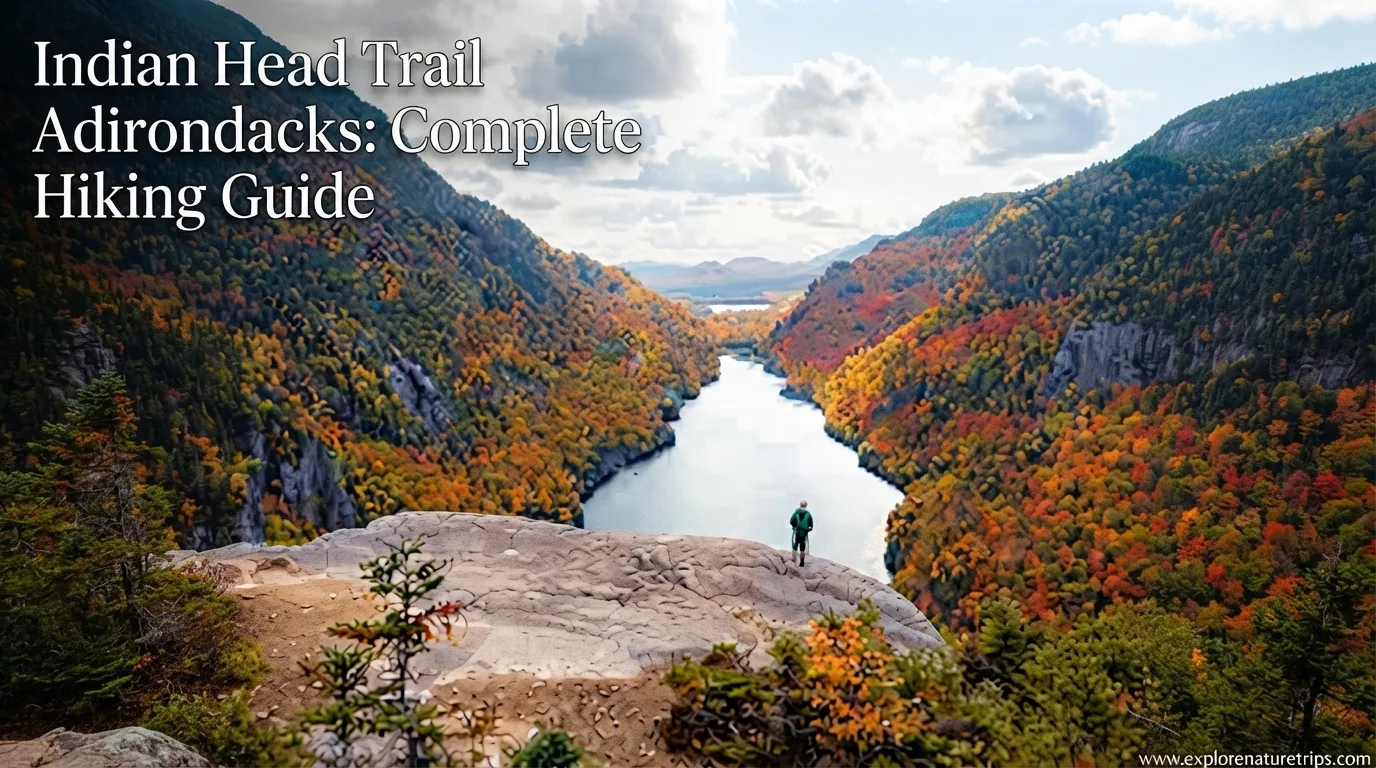
The Indian Head Trail in the Adirondacks is one of the region’s most scenic hiking routes, known for dramatic cliffside views over Lower Ausable Lake, mountain scenery, waterfalls, forest trails, and the distinctive Indian Head overlook.
One important planning detail is that the hike’s reported mileage varies depending on the route. The four trail guides reviewed for this article report distances ranging from 9.0 miles to 13.5 miles, while commonly described routes include both out-and-back and loop options.
One first-hand account recorded 13.5 miles, compared with 10.8 miles shown by AllTrails. Another guide lists a 12.6-mile loop, while Mountain-Hiking.com describes a 9.0-mile out-and-back.
That difference matters. If you are planning the hike, don’t prepare for the shortest mileage and assume that every route will take the same amount of time.
Where Is Indian Head Trail?
Indian Head is located in the Adirondack Mountains near Keene Valley, New York, with the route passing through land associated with the Adirondack Mountain Reserve (AMR) and the Ausable Club.
The hike’s defining viewpoint looks toward Lower Ausable Lake and the surrounding Adirondack High Peaks. The Adventures Atlas describes the viewpoint as sitting a little under 2,000 feet above Lower Ausable Lake, while Mountain-Hiking.com highlights views toward both Lower and Upper Ausable Lake.
For navigation, the supplied guides emphasize the St. Huberts Parking Area rather than attempting to drive directly to the hiking trail on Lake Road.
Driving Distances and Times
One of the supplied guides gives these approximate driving times:
| Starting point | Approximate drive |
|---|---|
| Lake Placid | 30 minutes |
| Hudson Valley | 3.5 hours |
| New York City | 4.5 hours |
| Boston | 5 hours |
| Montreal | 3 hours |
The same guide says the nearest bus stop is at Noonmark Diner, approximately 3 miles from St. Huberts parking.
Do You Need a Reservation for Indian Head?
Yes during the main reservation season.
The supplied guides consistently identify May 1 through October 31 as the period when an AMR parking reservation is required. The Nature Seeker describes May–October as the permit period, while The Adventures Atlas gives the more specific May 1–October 31 range. Mountain-Hiking.com likewise states that advance reservation is required from May 1 through October 31.
The reservation is important because access is controlled. The Adventures Atlas reports that the reservation system allows 70 reservations per day, and reservations can accommodate up to 8 people while reserving one parking space.
How Far Ahead Should You Book?
The common planning advice across the guides is 2 weeks ahead.
However, the supplied pages report different reservation release times:
- The Nature Seeker describes new hiking dates opening at 12:00 AM two weeks before the hike.
- The Adventures Atlas says reservations open 2 weeks in advance at 12 PM.
- Oh The Places We See reports a rolling 2-week schedule every Tuesday at 8 AM.
Because these details differ between the guides and may reflect different versions or descriptions of the reservation process, hikers should verify the current release time on the AMR reservation system before planning around a specific hour.
Best strategy: have your account ready before reservations open, choose your date in advance, and don’t wait several hours after the release.
Where Should You Park?
The supplied guides identify St. Huberts Parking Area as the principal parking location for Indian Head.
The Adventures Atlas says hikers must park at St. Huberts and then walk approximately 3 miles to the end of Lake Road before reaching the main Indian Head trail section.
Mountain-Hiking.com provides these trailhead coordinates:
44.149884, -73.767865
It also notes that the parking area requires advance reservation from May through October.
Important Parking Rules
These guides emphasize several practical points:
- Do not park illegally along Route 73.
- Use the designated parking area.
- Keep your reservation available when arriving.
- Expect reservation checks.
- Don’t assume you can simply arrive and find an unrestricted parking space.
- Download useful maps before starting because cell service may be unavailable.
The Adventures Atlas reports that the AMR parking lot operates from 5 AM to 7 PM.
How Long Does the Indian Head Hike Take?
Allow a full day.
The supplied guides report hiking times from 4–6 hours to 6–8 hours, while The Nature Seeker’s first-hand account took approximately 7 hours, including stops for photographs.
The difference is largely explained by route choice, distance, photo stops, waterfall detours, and time spent at the overlooks.
| Hiking style | Planning range |
|---|---|
| Shorter out-and-back | 4–6 hours |
| Typical longer route | 6–7 hours |
| Full loop with stops | 6–8 hours |
| First-hand reported loop | About 7 hours |
If you want time for photographs at Indian Head, Fish Hawk Cliffs, and Rainbow Falls, planning around 7 hours is more realistic than assuming the shortest four-hour estimate.
How Difficult Is Indian Head Trail?
The four guides describe the trail from moderate to hard.
Mountain-Hiking.com rates its 9-mile route as moderately challenging, with 1,650 feet of elevation gain and some short scrambles. The Nature Seeker describes a longer loop with approximately 2,000 feet of elevation gain and calls it hard. Oh The Places We See reports 2,100 feet of elevation gain over 12.6 miles.
The biggest challenge is not simply elevation.
Distance matters.
A route exceeding 12 miles can become tiring even when the elevation gain is moderate. The hike also combines road walking, forest trails, steeper climbing, rockier sections, ladders, and downhill terrain.
What Makes the Route Challenging?
Expect:
- Long mileage
- Approximately 1,650–2,100 feet of elevation gain
- Around 3 miles of initial road walking
- Steeper climbing toward the viewpoints
- Rock scrambles
- Ladder sections
- Long descents
- Additional distance for waterfall and viewpoint sections
For inexperienced hikers, the total distance should be considered before choosing the longer loop.
Indian Head Trail Route: What to Expect
The exact route depends on which version you choose, but the supplied guides repeatedly describe a progression from road walking into forest, climbing toward the overlooks, then descending through additional scenic sections.
1. Start With the Road Walk
The initial section is approximately 3 miles.
The route uses Ausable Road before continuing along Lake Road. This portion is less dramatic than the mountain section, but it serves as the approach to the main trail.
The Nature Seeker describes approximately 3 miles before reaching the Gillbrook Trail. The Adventures Atlas similarly describes roughly 3 miles along Lake Road.
2. Enter Gill Brook Trail
After the road approach, the route enters the Gill Brook/Gillbrook Trail section.
The Nature Seeker describes approximately 1 mile on the red trail, with waterfalls and opportunities to choose more scenic sections.
This is where the hike begins to feel more like a mountain trail rather than a long approach road.
3. Climb Toward Indian Head
The route then transitions toward the Indian Head Crossover Trail.
The Nature Seeker describes another approximately 1–2 miles of climbing, including stairs and rock scrambles.
This is one of the more physically demanding parts of the hike.
4. Reach the North Overlook
The North Overlook is one of the first major viewpoints.
It provides a useful preview of the larger scenery before reaching the most recognizable Indian Head viewpoint.
Take a short break here if needed, especially if you’ve already completed the long road approach.
5. Visit Fish Hawk Cliffs
From the main intersection, hikers can visit Fish Hawk Cliffs.
The Nature Seeker reports approximately 200 feet of descent and says the overlook is less than 0.5 mile from the intersection.
This section adds some extra work because you must descend and then regain that elevation.
The reward is a quieter viewpoint with impressive views toward the surrounding landscape.
6. Reach Indian Head Overlook
The main attraction is Indian Head Overlook.
This broad rocky viewpoint overlooks Lower Ausable Lake and the surrounding Adirondack landscape. It is the section that gives the hike much of its reputation.
The Nature Seeker’s first-hand account reports spending approximately 1 hour at the main overlook.
That is a useful reminder: don’t calculate your hiking schedule using walking time alone.
7. Descend Toward Rainbow Falls
After the overlooks, the route turns downhill.
The descent includes switchbacks and ladder sections before connecting with lower sections of the trail.
One of the major attractions afterward is Rainbow Falls.
The Nature Seeker describes Rainbow Falls as a major highlight before continuing onto the East River Trail.
8. Continue Along East River Trail
The East River Trail section is approximately 1.5 miles according to The Nature Seeker.
This part provides a quieter forest experience after the dramatic viewpoints.
9. Continue Toward Beaver Meadow Falls
The route then connects with the West River Trail.
The Nature Seeker reports approximately 2–3 miles on this section and identifies Beaver Meadow Falls as another major waterfall along the way.
This gives the longer loop a strong combination of:
cliffs + lakes + forests + waterfalls.
Indian Head’s Main Scenic Highlights
There is more than one viewpoint worth seeing.
| Highlight | Why it matters |
|---|---|
| North Overlook | Early major mountain viewpoint |
| Fish Hawk Cliffs | Quieter cliff scenery |
| Indian Head Overlook | Signature viewpoint over Lower Ausable Lake |
| Rainbow Falls | Major waterfall highlight |
| Beaver Meadow Falls | Additional waterfall on the return |
| Lower Ausable Lake | Defining landscape below Indian Head |
| Upper Ausable Lake | Additional mountain-lake scenery |
The Adventures Atlas specifically presents Indian Head as a viewpoint overlooking Lower Ausable Lake and the surrounding High Peaks, while Mountain-Hiking.com highlights views of both Lower and Upper Ausable Lake.
Loop or Out-and-Back: Which Is Better?
Both approaches appear in the supplied guides.
Out-and-Back
The shorter approach is attractive if you want a more straightforward hike.
Mountain-Hiking.com lists its route as a 9.0-mile out-and-back, while the Adventures Atlas also describes an out-and-back option of approximately 11 miles.
Best for: hikers who want a simpler route structure.
Longer Scenic Loop
The loop combines the main viewpoint with additional scenery and waterfalls.
The Nature Seeker recommends a 13-mile lollipop loop and reports completing 13.5 miles personally. Oh The Places We See lists a 12.6-mile loop.
Best for: hikers who want the fullest combination of viewpoints and waterfalls and have enough time and endurance.
What Should You Pack?
For a route that can reach 12+ miles, preparation matters.
The supplied guides recommend practical hiking essentials including:
- Water
- High-energy snacks
- Sturdy hiking boots
- Layers
- Rain protection
- First-aid supplies
- Headlamp
- Phone charger
- Hiking poles
- Sunscreen
- Bug protection
One guide specifically recommends carrying at least 3 liters of water for the longer hike.
Download Your Map Before Starting
This is one of the most useful practical recommendations from the material.
The Nature Seeker says phone signal is poor for much of the route and recommends downloading a map before hiking. Mountain-Hiking.com similarly warns that hikers should allow for zero cell service during the hike.
Don’t depend on live cellular navigation once you’re deep into the route.
When Is the Best Time to Hike Indian Head?
The supplied guides emphasize spring through fall, with May through October being the main reservation period.
Summer
Summer provides long daylight hours but can bring larger crowds.
If you want a quieter experience, the experience reports suggest that weekdays can be preferable to busy weekends. One guide specifically describes completing the hike on a Wednesday in August and starting early to avoid crowds.
Fall
Fall is particularly attractive for hikers interested in Adirondack foliage.
The Nature Seeker specifically suggests making a reservation for early October when targeting fall foliage.
Winter
The reservation rules differ outside the main May–October period, but winter conditions are a different hiking proposition. The supplied guides indicate that November through April falls outside the standard reservation period described for the main season.
Winter hikers should not assume that a lack of reservation requirements means the trail will have summer-like conditions.
Sunrise, Midday, or Sunset?
The Adventures Atlas discusses three useful timing choices:
- Sunrise: fewer people and potential atmospheric conditions
- Midday: easier visibility but potentially more crowded
- Sunset: attractive light for photography
For sunset photography, the guide recommends arriving approximately 1–2 hours before golden hour and carrying a headlamp for the return.
For most hikers, however, an early start provides a useful balance between daylight, crowd avoidance, and enough time to complete a long route.
Rules to Know Before You Go
The supplied guides emphasize that Indian Head is not a hike where visitors should simply arrive and ignore access rules.
Important points include:
- Obtain the required reservation during the main season.
- Stay on designated trails.
- Do not park illegally.
- Follow AMR access rules.
- Do not bring dogs where prohibited by AMR rules.
- Do not enter restricted buildings.
- Avoid relying on cell service.
- Practice Leave No Trace principles.
The Adventures Atlas specifically emphasizes staying on trails, carrying out trash, respecting wildlife, minimizing campfire impacts, and being considerate of other visitors.
What Makes Indian Head Worth the Effort?
The attraction is not one feature alone.
It is the combination of a dramatic viewpoint, mountain lakes, forest, waterfalls, and changing terrain.
The hike begins relatively gently, becomes more demanding as you climb, rewards you with the major overlook, and then continues through additional scenic sections if you choose the longer route.
That variety is why the supplied guides repeatedly describe Indian Head as one of the Adirondacks’ most scenic hikes.
A Practical Indian Head Hiking Plan
For a first visit, the following planning sequence keeps the day simple:
1. Choose your route.
Decide whether you want the shorter out-and-back or a longer scenic loop.
2. Check the current reservation requirements.
For the main season, plan around the May 1–October 31 reservation period described by the guides.
3. Prepare 2 weeks ahead.
The supplied guides consistently emphasize the importance of the 2-week reservation window, although their reported release times differ.
4. Download your map.
Do this before leaving an area with reliable service.
5. Arrive prepared for a long day.
If choosing the longer loop, plan for roughly 6–8 hours rather than treating it as a short viewpoint walk.
6. Allow time for the overlooks.
Don’t rush through North Overlook, Fish Hawk Cliffs, or Indian Head.
7. Add the waterfalls if your route allows.
Rainbow Falls and Beaver Meadow Falls add substantial scenic value.
8. Carry enough water and food.
A 3-liter water target is specifically recommended in one of the supplied guides for the longer hike.
FAQs
How many miles is the Indian Head Trail?
The supplied guides report different distances depending on the route. Figures range from 9.0 miles for an out-and-back to 12.6 miles and 13.5 miles for longer loop versions.
How long does the Indian Head hike take?
Plan for approximately 6–8 hours for a longer loop. Other reports give 4–6 hours for a shorter route, while one first-hand account completed its route in about 7 hours including photo stops.
How much elevation gain does Indian Head have?
The supplied guides report approximately 1,650 to 2,100 feet of elevation gain, depending on the route used.
Do you need a permit for Indian Head?
The supplied guides state that an AMR reservation is required during May 1 through October 31. The reported reservation process and release times differ between the guides, so check the current AMR system before your trip.
How far in advance should I reserve Indian Head?
The guides repeatedly recommend planning 2 weeks in advance. Because the reported release times differ—12 AM, 8 AM Tuesday, and 12 PM—verify the current reservation schedule before booking.
What is the most famous viewpoint?
The main Indian Head Overlook is the signature viewpoint, with views toward Lower Ausable Lake and the Adirondack mountains. Fish Hawk Cliffs and North Overlook provide additional viewpoints.
Is Rainbow Falls part of the hike?
Rainbow Falls can be incorporated into the longer route. The Nature Seeker includes it in its recommended loop, while the Adventures Atlas specifically provides a route section for reaching Rainbow Falls.
Is Indian Head difficult?
It ranges from moderate to hard, depending on the route and hiker. The main challenge is the combination of long mileage, elevation gain, climbing, rockier sections, and descents rather than technical climbing alone.
Is there cell service?
You should not rely on cell service. Mountain-Hiking.com says hikers should allow for zero cell service, while The Nature Seeker also warns that phone signal is poor for much of the hike.
What should I bring?
For the longer route, bring water, food, sturdy hiking footwear, layers, rain protection, a first-aid kit, a headlamp, and navigation resources. One supplied guide recommends at least 3 liters of water.
Final Thought
The Indian Head Trail Adirondacks experience is best planned as a substantial day hike rather than a quick viewpoint walk. Depending on the route, the supplied guides report approximately 9.0–13.5 miles, 1,650–2,100 feet of elevation gain, and roughly 4–8 hours on the trail.
The most important planning issue is the AMR reservation during the main May–October season. After that, the biggest decision is route length: a shorter out-and-back keeps the day simpler, while a longer loop can combine Indian Head, Fish Hawk Cliffs, Rainbow Falls, Beaver Meadow Falls, and additional forest scenery.
Most importantly, build your plan around the actual route you intend to hike, download navigation before losing service, carry enough water, and leave plenty of time to enjoy the viewpoints rather than racing to the finish.

Hi, I’m Marcus! I love exploring the outdoors and discovering incredible places. Through ExploreNatureTrips blog, I share my travel experiences, useful tips, and recommendations for the best sights, trails, and destinations to visit.


3 Comments