What to Do in Big Sur: 5 Must-See Places and a Complete Highway 1 Guide

Big Sur is a spectacular stretch of California’s Central Coast where Highway 1 winds between rugged cliffs, the Pacific Ocean, redwood forests, beaches, waterfalls, and scenic viewpoints. The area stretches roughly 85–90 miles between the Carmel and San Simeon areas, making the drive itself one of the main experiences.
For a first visit, you do not need to see every trail or viewpoint. A well-planned route can combine iconic scenery with a few short walks, a beach stop, wildlife viewing, and time to simply enjoy the coastline.
The biggest mistake is trying to rush through the area. The road has sharp curves, narrow sections, frequent viewpoints, and many places where you will want to stop for photographs.
1. McWay Falls: The Big Sur View You Should Not Miss
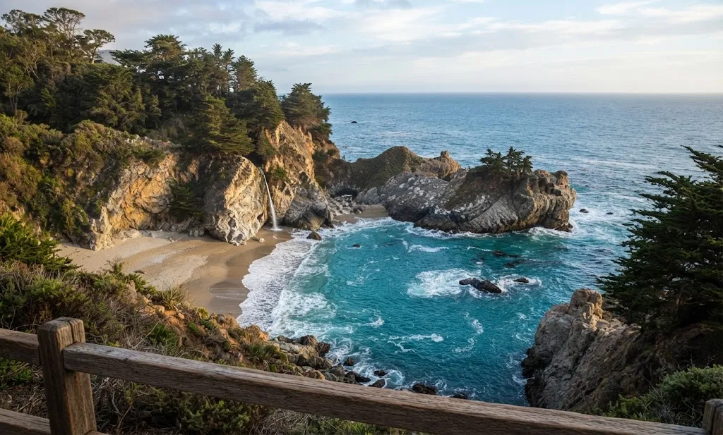
McWay Falls is one of the most recognizable sights in Big Sur. The waterfall drops approximately 80 feet toward a beautiful coastal cove inside Julia Pfeiffer Burns State Park.
The easiest way to see it is from the designated overlook. The Waterfall Overlook Trail is about 0.5 mile round trip, while another source describes the route as approximately 0.6 mile round trip.
The short walk makes McWay Falls suitable for travelers who do not want a demanding hike. You can spend more time enjoying the view rather than climbing a long trail.
The cove itself should be viewed from the permitted areas. Access to the beach below the waterfall is prohibited because of hazardous and fragile conditions.
Best experience: Visit when the light is good and allow extra time for photographs.
One useful location fact is that McWay Falls is around 35–45 minutes south of Bixby Creek Bridge, making it easy to combine the two attractions during a Highway 1 drive.
2. Bixby Creek Bridge: Stop for the Classic Highway 1 View
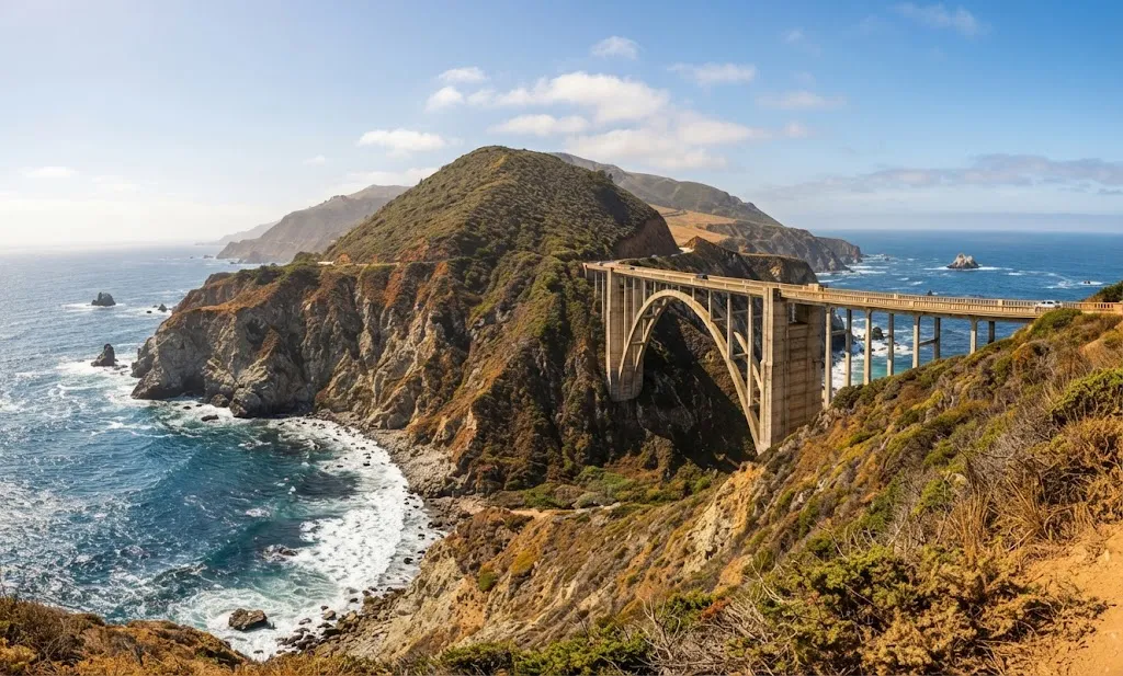
Bixby Creek Bridge is one of the defining landmarks of the Big Sur drive. The bridge was completed in 1932 and spans the canyon in a dramatic coastal setting.
Different measurements in the travel material describe the bridge’s height at roughly 260–280 feet, but the important experience is the setting: mountains, canyon, ocean, and the sweeping Highway 1 landscape all come together here.
Parking around the bridge can become difficult during busy periods, especially in good weather. Instead of stopping for only a quick photograph, look for safe designated viewpoints and take time to appreciate the scenery from different angles.
There is no pedestrian path across the bridge itself, and the road is narrow, so visitors should avoid walking onto the roadway for photographs.
A particularly useful strategy is to explore the viewpoints around Hurricane Point after crossing the bridge. These elevated locations can provide wider views of the coastline.
3. Pfeiffer Beach: Look for the Purple Sand
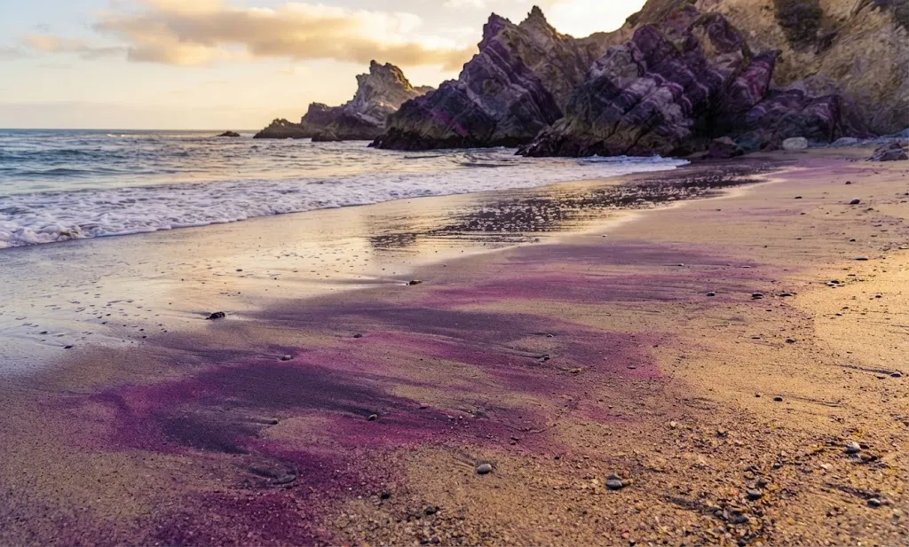
Pfeiffer Beach offers a completely different experience from the waterfall and bridge. It is known for its unusual purple-colored sand, coastal rock formations, waves, and the famous Keyhole Rock.
The purple color comes from mineral particles washed down from the surrounding hills.
The access road from Highway 1 is narrow and winding. The drive along Sycamore Canyon Road is approximately 2 miles, and larger RVs and trailers are not permitted on the road.
Because parking is limited, arriving early can make the visit much easier.
At low tide, visitors may explore tide pools and walk along the beach. Swimming is not recommended in the source material.
Photographers often pay special attention to sunset and to the winter period when sunlight can pass through Keyhole Rock.
Photography tip: Instead of taking only one wide photograph, spend time looking for the contrast between the purple sand, dark rocks, blue water, and surrounding cliffs.
4. Point Lobos: Coastal Trails and Wildlife
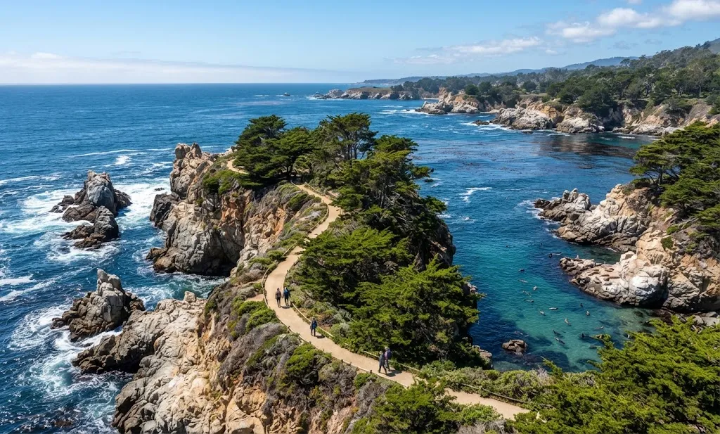
Point Lobos State Natural Reserve sits near the northern side of the Big Sur area and provides a combination of short trails, rocky coastline, sheltered coves, and opportunities to observe wildlife.
China Cove is one of the standout locations, with jade-green water and a scenic beach that should be viewed from the appropriate trail areas.
The Bird Island Trail is less than 1 mile, making it a practical option when your schedule is tight.
Other useful trail numbers include:
| Trail | Distance | Approximate Time |
|---|---|---|
| Sand Hill Trail | 0.4 mile | 15–20 minutes |
| Bird Island Trail | 0.8 mile | 25–30 minutes |
| Point Lobos larger route | Several hours | Up to 4 hours |
Point Lobos is also useful for wildlife watching. Depending on the season and conditions, you may see sea lions, harbor seals, sea otters, seabirds, and potentially whales.
If you want to explore the reserve without spending an entire day, choose 1–2 short trails rather than attempting to cover everything.
5. Garrapata State Park and Calla Lily Valley
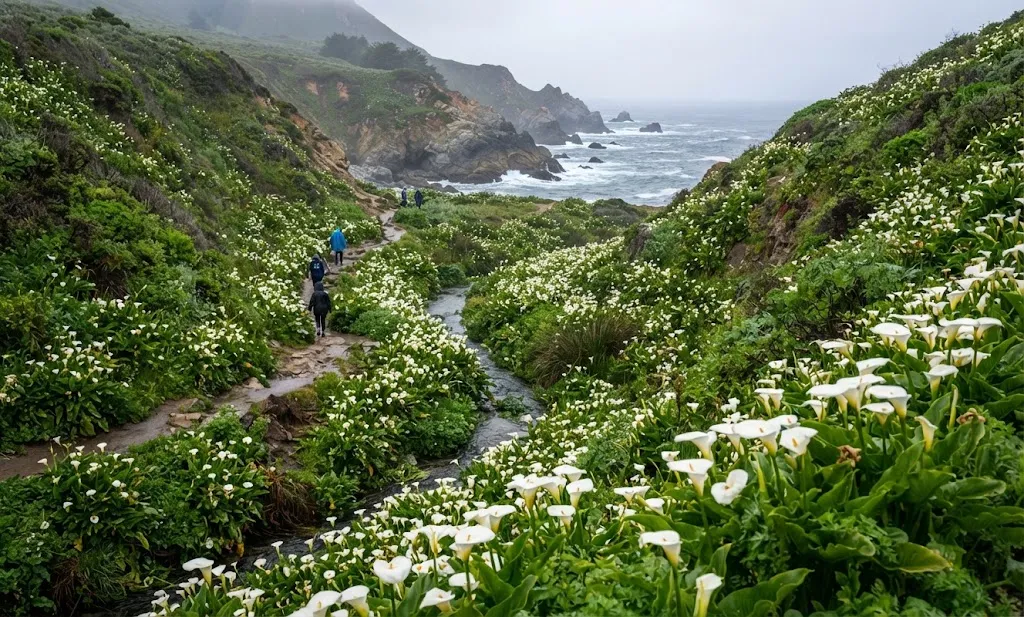
Garrapata combines coastal trails, beaches, cliffs, flowers, and wildlife. It is particularly interesting during spring when wildflowers add color to the coastal landscape.
One suggested route is the Soberanes Point and Whale Peak Trail, approximately 2 miles in a loop and generally taking around 40–50 minutes according to the referenced travel material.
Another option is the Calla Lily Valley area.
The Calla Lily Valley is especially notable during its seasonal bloom. Peak flowering is generally described as mid-February through mid-March, although another source extends the flowering period into April.
If flowers are your main reason for visiting, February and March can be especially worthwhile.
Harbor seals may also be seen in the area during spring.
Other Big Sur Stops Worth Adding
The five locations above provide a strong first-time route, but Big Sur has several additional stops that fit naturally into the same journey.
Point Sur Light Station
Point Sur Light Station combines coastal scenery with California history.
The light station began operating in August 1889. Historically, 4 lighthouse keepers operated the station around the clock.
Today, visitors can experience the location through guided tours.
The walking portion is approximately 1 mile, with about 350 feet of elevation gain, and the full guided experience can take around 3 hours.
Listed tour times include 10:00 a.m. on weekend days and 1:00 p.m. on Wednesdays in the referenced material.
If you enjoy historic places, this can be a useful alternative to spending the entire day on beaches and trails.
Sand Dollar Beach
Sand Dollar Beach is a long, crescent-shaped beach near the southern portion of the Big Sur coastline.
It is approximately 30 miles south of Big Sur Station and is described as the longest beach along the Big Sur coast.
Visitors can:
- Walk along the sand
- Enjoy a picnic
- Watch surfers
- Explore tide pools at low tide
- Look for coastal wildlife
- Enjoy the surrounding cliffs
- Watch sunrise or sunset
Access involves steep stairs, so visitors should consider mobility and footwear before heading down.
The beach is open year-round and is generally busier during summer.
Old Coast Road
For travelers who want a more adventurous experience, Old Coast Road provides a different side of Big Sur.
The route is approximately 10 miles long and connects the area around Bixby Creek Bridge with Andrew Molera State Park.
It is a dirt route with ruts, potholes, steep sections, and limited opportunities to pull over.
A 4WD, high-clearance vehicle is recommended in the referenced material, and the road should be avoided during or after wet weather.
Driving during daylight hours is important because of the road conditions.
Piedras Blancas Elephant Seal Rookery
At the southern end of the Big Sur region, the Piedras Blancas area provides an opportunity to observe northern elephant seals.
The animals can spend up to 10 months at sea and dive to depths of approximately 1,000–3,000 feet.
Male elephant seals can reach about 16 feet in length and weigh up to approximately 2,300 kg.
The largest concentrations are noted around late January, early May, and late October, although seals can be present during other periods as well.
The viewing area provides an easy way to observe them without needing a strenuous hike.
Pfeiffer Big Sur State Park and Redwoods
Big Sur is not only about ocean views.
Pfeiffer Big Sur State Park offers access to towering coast redwoods and trails alongside the Big Sur River.
The River Path is only about 0.6 mile, making it an excellent short walk when you want to experience the forest without committing to a long hike.
This is a good place to balance a coastal itinerary with a quieter redwood experience.
A Simple Big Sur One-Day Itinerary
If you have only 1 day, planning the route in advance can prevent unnecessary backtracking.
| Time | Suggested Stop |
|---|---|
| 8:00 a.m. | Begin near Point Lobos |
| Morning | Explore a short Point Lobos trail |
| Late morning | Garrapata coastal area |
| Around midday | Calla Lily Valley when in season |
| Afternoon | Bixby Creek Bridge and nearby viewpoints |
| Late afternoon | Continue south along Highway 1 |
| Around sunset | McWay Falls |
| Evening | Dinner or return toward your accommodation |
The exact timing depends on traffic, parking, trail stops, weather, and how long you spend taking photographs.
If you are coming from the San Francisco Bay Area, a leisurely day can be possible, but returning the same day may make the schedule long.
A Better Two-Day Plan
With 2 days, the experience becomes less rushed.
Day 1
- Point Lobos
- Garrapata State Park
- Calla Lily Valley
- Bixby Creek Bridge
- Hurricane Point
- Point Sur area
Day 2
- Pfeiffer Beach
- Pfeiffer Big Sur State Park
- McWay Falls
- Limekiln area
- Sand Dollar Beach
- Piedras Blancas elephant seals
This approach gives you more time for photographs and short walks instead of spending the entire trip inside the car.
Best Hiking Options by Difficulty
Not every Big Sur visitor wants a challenging hike. The following options make it easier to match a trail to your available time.
| Level | Trail | Distance |
|---|---|---|
| Easy | McWay Falls Overlook | 0.5 mile |
| Easy | Sand Hill Trail | 0.4 mile |
| Easy | Bird Island Trail | 0.8 mile |
| Easy | Garrapata Bluffs Trail | 1.2 miles |
| Moderate | Limekiln Falls Trail | 1.5 miles RT |
| Moderate | Buzzard’s Roost | 3 miles RT |
| Advanced | Tanbark Trail to Tin House | 6 miles RT |
| Advanced | Cone Peak Trail | 10 miles RT |
A particularly demanding option mentioned in the travel material is the Boronda/Timber Top route, which is approximately 6 miles round trip with around 2,500 feet of elevation gain.
Do not choose a difficult trail simply because it appears on a list. Consider your fitness, daylight, weather, footwear, water, and available time.
When Is the Best Time to Visit Big Sur?
Big Sur can be visited throughout the year, but each season offers a different experience.
| Season | Months | What to Expect |
|---|---|---|
| Spring | March–May | Wildflowers, greenery, waterfalls |
| Summer | June–August | Generally favorable weather but more visitors |
| Fall | September–October | Warmer days and potentially fewer crowds |
| Winter | November–February | Quieter atmosphere but possible storms and road problems |
For Calla Lily Valley, the most important seasonal window is generally mid-February through mid-March, with flowering potentially continuing later.
Morning fog is common in Big Sur. A cold, cloudy morning does not necessarily mean the entire day will remain that way.
How Long Should You Spend in Big Sur?
A quick visit can be completed in 1 day, but that does not mean one day is enough to experience everything.
A useful way to decide is:
- 1 day: Focus on the major viewpoints and 2–3 short stops.
- 2 days: Add beaches, redwoods, wildlife and more hiking.
- 3 days: Allow more flexibility for photography, longer trails, restaurants and slower driving.
One travel experience described spending 3 full days in the area, while another road-trip account notes that the route can technically be completed in a single day.
The key difference is how much time you want outside the vehicle.
Big Sur Road Trip Tips You Should Know
Big Sur is beautiful partly because development is limited, but that also means preparation matters.
1. Download offline maps
Cell service can be limited or unavailable along sections of the route.
2. Fuel up before entering
Gas stations are limited, so do not rely on finding fuel exactly when you need it.
3. Carry food and water
Restaurants and stores are not evenly distributed along the coastline.
4. Dress in layers
Morning conditions can be foggy and chilly, while temperatures may become warmer later in the day.
5. Wear proper shoes
Even short trails can include uneven surfaces, stairs, rocks, or steep sections.
6. Do not rush Highway 1
The road has curves, narrow shoulders and frequent viewpoints. Pull over safely when you need to let faster traffic pass.
7. Check road conditions
Storms, landslides and other conditions can affect access.
8. Respect restricted areas
Some beaches, cliffs and trails have restrictions because of safety, erosion, wildlife, or environmental sensitivity.
What to Pack for a Big Sur Day
A practical day-trip bag can include:
- Comfortable walking shoes
- Reusable water bottle
- Snacks or lunch
- Extra layers
- Sunscreen
- Sunglasses
- Hat
- Camera or phone
- Portable battery
- Offline map
- Small daypack
If you plan to camp, add warmer clothing because foggy nights can feel cold.
FAQs
Is Big Sur worth visiting for just one day?
Yes. A 1-day visit can cover several major sights, particularly if you prioritize Point Lobos, Garrapata, Bixby Creek Bridge, and McWay Falls. However, a longer stay allows more time for beaches, hiking, wildlife, and slower scenic driving.
What are the 5 must-see places in Big Sur?
A strong first-time route is McWay Falls, Bixby Creek Bridge, Pfeiffer Beach, Point Lobos State Natural Reserve, and Garrapata State Park/Calla Lily Valley.
How high is McWay Falls?
McWay Falls is approximately 80 feet high.
How long is the McWay Falls trail?
The commonly described overlook route is about 0.5 mile round trip, while another measurement gives approximately 0.6 mile round trip.
When does Calla Lily Valley bloom?
Peak bloom is generally around mid-February through mid-March, with flowering potentially continuing into April depending on conditions.
Can you walk across Bixby Creek Bridge?
The referenced travel information notes that there is no pedestrian path on the bridge itself. Because the roadway is narrow, visitors should stay in safe viewing areas rather than walking into traffic lanes.
How many days do you need in Big Sur?
1 day works for major highlights, 2 days provides more breathing room, and 3 days allows a much slower combination of hiking, beaches, wildlife, photography, and scenic driving.
Is Pfeiffer Beach the same as Pfeiffer Big Sur State Park?
No. They are different destinations. Pfeiffer Beach is a coastal beach known for its purple-colored sand and rock formations, while Pfeiffer Big Sur State Park is known for redwoods, the Big Sur River, and forest trails.
What should I bring to Big Sur?
Bring water, food, layers, comfortable shoes, sun protection, a camera or phone, and offline maps. Limited services and unreliable cell reception make preparation particularly useful.
Final Thoughts
The best way to experience Big Sur is to treat Highway 1 itself as part of the destination. McWay Falls provides the iconic waterfall view, Bixby Creek Bridge delivers the classic coastal landmark, Pfeiffer Beach adds unusual geology and beach scenery, Point Lobos combines trails and wildlife, and Garrapata brings together cliffs, flowers, and ocean views.
With the right pace, even a 1-day visit can be rewarding. If you have 2–3 days, you can slow down, explore more trails, watch wildlife, visit beaches, experience the redwoods, and spend more time enjoying the scenery instead of watching the clock.
The most valuable planning rule is simple: leave room for the unexpected. Big Sur is a place where a short viewpoint stop can easily become the best part of the day.
Hi, I’m Marcus! I love exploring the outdoors and discovering incredible places. Through ExploreNatureTrips blog, I share my travel experiences, useful tips, and recommendations for the best sights, trails, and destinations to visit.